    |
Bird Man's AT Journal
Trail Updates and Photos from the 2002 AT "Flip-Flap" Hike
© Bruce Nichols - 2002
The Last 400 Miles - Part 2
Delaware Water Gap to Harpers Ferry
previous story | story index
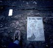
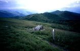
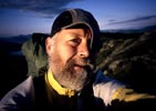
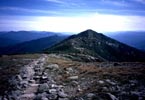
| I climbed up out of the gap the next morning in bright sunshine. Once on the ridge, the trail would run southwest for 8 or 10 miles without much change in elevation before finally dipping down a 1000 feet or so into the next gap and then climbing out to do it all over again. The northern half of PA has an infamous reputation for its sharp, unpredictable rocks. The mountains here are composed of layer upon layer of hard sedimentary stone that, over the millennia, have tilted to the vertical and slowly eroded away. The ridgelines are studded with long stretches of exposed strata that has cracked and crumbled into a rocky jumble. The rocks are very unstable and even boulders as large as a living room recliner can tip unpredictably when stepped on. Navigating these sections of trail took unceasing care and concentration and left little time for observing the surrounding forest. Even where the trail was relatively smooth, bread loaf sized points of rock would protrude through the surface and require constant vigilance. When I first passed through Harper's Ferry back in July, a friendly hiker at the ATC office had offered to drive me to a local restaurant for breakfast and then back to the train station so I could catch the noon train into Washington, DC. Sue Ann Cherneskey lived in Pennsylvania not far from where the trail passed through Wind Gap. We exchanged email addresses and I added her to my trail update list. As I got closer to PA, I received an email from her offering me a place to stay for the night and help in resupplying if I needed it. I decided to take her up on the offer and called a few days before entering PA to arrange a pick up. I dropped into Wind Gap on the Saturday the 28th of September and gave Sue Ann a call. She picked me up at the Post Office and we drove to her apartment where I had a chance to shower and do laundry. Sue Ann was an occasional volunteer at Hawk Mountain Sanctuary one of the best locations in the Eastern US to view the fall hawk migrations and suggested that it would be an interesting place to spend a few afternoon hours. At the sanctuary we stopped at the visitors center for a bit then walked the half-mile to North lookout. A small clutch of volunteer census takers and visitors made up of avid birders and curious tourists sat on the rocky outcrop. Binoculars dangled from straps or were pressed to searching eyes. When a bird was sighted its location would be called out and half a dozen experts would call back and forth till there was a consensus and the species that was being observed was positively identified. Another volunteer with a tally sheet would add this migrant to the record. It was a good afternoon for birds. In about 2 hours we watched 4 bald eagles, numerous osprey, sharp-shinned and broad wings hawks, kestrels, and a few other species sail by on a brisk westerly breeze. I spent the night on Sue Ann's sofa, bought her breakfast at a local diner in the morning to say thank you, and was back on the trail heading south once again. I'd missed the "trucks" during the last few days after the heavy rains coming out of New Jersey, but our paths crossed once again in one of the most unusual places along the trail. On a long ridge above Palmerton, PA the trail passes through a bizarre moonscape of barren rock studded by the stark skeletons of bleached dead tree trunks. For decades the valley to the west had been the home of a zinc smelter that had belched clouds of toxic smoke which prevailing winds had wafted over this stretch of trail. The zinc, cadmium, and other heavy metals had rained down on the mountaintop turning it into a Superfund site. As you approach this section, warning signs caution against straying from the trail and advise that young children and pets had better be left at home. The smelter was closed quite a few years ago and the land has just begun to show sparse signs of recovery but this three or four-mile section of the AT provides stark testimony to the disastrous effects of unchecked industrialization. The "Trucks" warned me of the steep descent into Lehigh Gap at the end of the AT Superfund zone. And the rocky jumble that dropped down to the Lehigh River lived up to their description. I had to pick my way very carefully down through a maze of loose, sharp edged rocks and boulders while trying to enjoy the spectacular view of the valley below. I'd found a plastic guide book protector that I'd assumed had been dropped by one of the Trucks and when I passed the parking lot where the red truck was parked I lifted the windshield to tuck it where it would easily be found. When I let the blade slap back onto the window I was surprised by an incredibly loud car alarm. I leapt back then looked around sheepishly. In a van nearby some telephone workers were eating lunch and I walked over to explain that I was simply returning a dropped item of friends and not attempting to break into the truck. Fortunately the alarm stopped its howling before I reached the van and I delivered my explanation in relative silence. For the next few days the PA rocks were the main feature and experience along the trail. The walking was a bit tiring requiring caution and making it difficult to fully enjoy the fall color that was seeping into the surrounding forest. It took two and a half days to walk the 45 miles back to Hawk Mountain, a distance that had been covered by car in just over an hour. In a shelter at the base of the sanctuary, I found a copy of the Peace Pilgrim book that I had first seen in southern Virginia. My trail buddy Clint had picked it up and carried it to PA. He'd left a note in the front cover recommending the book and indicating the pages of the passages referencing the AT. In the register I found several entries that spoke highly of the book and felt a wave of gratitude for the opportunity to be walking the trail in Peace's footsteps on the 50th anniversary of her journey. The miles were rolling by. On October 4th I passed the 2000-mile mark on another rain soaked day. That night, in Rausch Gap Shelter, fog pressed down on the wet earth and visibility was almost zero. I was surprised to awaken a little after midnight to the sound of geese flying overhead. Fog still wrapped around the shelter and I wondered if the birds were flying blind or sailing through clear air somewhere above the clouds. When I rose again a few hours later and ventured a dozen yards away from the shelter to answer nature's call, I was delighted to see stars overhead for the first time in several days. Morning arrived with glorious sunshine and cooler temperatures as I set out on one of the longer mileage days of my journey. I was anxious to get to Duncannon, PA and the Susquehanna River. This was the spot that Mildred (Peace Pilgrim) and her companion Dick Lamb had finished their flip-flop hike in October of 1952. I was running low on food - a mixed blessing, since it meant my pack was getting lighter - and needed to do a little resupply. A couple days earlier I had to ask the "trucks" to pick up a couple of bagels for me on their drive south when I realized I did not have enough of these lunch time staples to get me to Duncannon. I was also looking forward to spending a night in the Doyle Hotel, a place that has become an AT icon. Built around the turn of the century by Anheuser-Busch and run for many years by the Doyle family, the hotel had fallen on hard times and deteriorated. A new owner is trying to gradually renovate and restore the grand old building to some semblance of its glory days. But life at the Doyle still revolves around the bar and a somewhat motley assortment of characters make up the "regulars" and long term residents of the Doyle. But a big banner hangs out front welcoming AT hikers most of whom probably qualify as being a bit "motley" in their own right and the price is right at $15 a night for a room with sheets on the bed and a clean towel. I could have walked the 30 miles from Rausch Gap to Duncannon in a single day but opted to stop a few miles short of town and spend one more night in a shelter. I could walk into town early in the morning, grab a big breakfast at the truck stop the trail passed before the final road mile to the Doyle, and still have a whole day to take care of my town chores. I ate the last of my Lipton dinners and was left with a handful of granola and a Snickers bar to get me into town in the morning. I didn't sleep well that night, but had the pleasure in my sleeplessness of watching a parade of stars slowly rise into and cross a large gap in the trees to the south east of the shelter. First came the Pleiades followed by Taurus and the bright star Aldebaran. Next it was the belt of Orion slipping up out of the leafy branches and beginning its slow arc upwards. And finally, near dawn, brilliant Sirius, the dog star and brightest of all the stellar sky objects. I'd also seen two meteorites flash across the open section of sky in the opposite direction of the processing constellations. I'd dozed between sessions of sky watching and, though a bit tired in the morning, was energized by the thought that Duncannon was only a couple of hours walk away. The "Trucks" were just getting ready to leave a parking lot on the north side of the Susquehanna River when I walked out of the woods. We chatted a bit and I invited them to have dinner with me to repay them for their assistance earlier in the week. We agreed to meet at 6 PM at the Doyle and I struck out across the bridge that spanned the river. After breakfast at the truck stop, I walked into Duncannon on a sunny warm Sunday morning. Like many working class towns in the Northeast, Duncannon has seen better days. Many of the stores on the main street of town were empty, their dark and dirty windows staring out at the road like so many blind eyes. But the town folk were friendly and I received a number of "Good mornings' from people I encountered on the street and a few waves from passing motorists. Arriving at the Doyle around 10 AM I discovered that the check in time there is noon. That's when the bar opens and it is at the bar that all business at the Doyle is conducted. On the wrap around porch on the second floor a few hiker-types were sitting at a table reading the Sunday paper and sipping on coffee or beers. Seeing my pack, they invited me up. Two were indeed active hikers though one of those had managed to get sidetracked at the Doyle for most of a week. The other three had been at the Doyle for a considerably longer time. Two of those had originally been hiking but for one reason or another had settled for longer stays at this run down establishment. I gathered from the conversation that there were a number of long-term residents at the Doyle and they seemed to have become a makeshift family of sorts. At noon the bar opened and after about another hour of delays, I finally got to drop my things into a funky room on the 3rd floor. There were some un-patched holes in the wall where work on wiring or plumbing had been done. A bare light bulb hung from the ceiling with a brown extension cord running from a socket in the light fixture over to the wall and then to another lamp. I didn't see any other electrical outlets in the room. The bathroom across the hall had a plywood floor and several layers of ancient exposed paint in various stages of peeling from the walls; but the shower had good pressure and the toilet worked - what more could one possibly want. I walked down the street to the laundry, was offered a lift to the grocery store as my cloths churned in the machine and finished my town chores in short order. At 6 "The Trucks", Dale and Matthew arrived and we walked down the street to a local pizza place where I ordered the "small stromboli" and was confronted with a folded in half pizza full of mozzarella and ricotta cheese and an assortment of vegetables that left me a couple of notches beyond full by the time I had cleaned my plate. Ah the dietary immunity of long distance hiking. When I returned to the Doyle, I repacked my gear and crawled into the double bed that took up most of the small room. The mattress was a real piece of work. I'm not sure how old it was, but it was of some kind of inner spring construction and it seemed that all the springs functioned independently of each other. There were lumps and bumps and prodding protuberances liberally and randomly spread about the surface. By carefully arranging myself on a diagonal in a slightly contorted shallow "s" curve I managed to avoid the most obnoxious springs, but remaining comfortable proved to be a nightlong challenge. Before dawn I was across the street having breakfast at a cozy lunch counter in the company of a section hiker who had also spent the night at the Doyle. I hung around the hotel for another hour or so after breakfast then checked for mail at the Post Office, sent some no longer need items home, walked the paved mile of trail out of town and returned to the woods. After Duncannon the notorious "PA rocks" dramatically diminish in number and the walking becomes more enjoyable. The perpetual ridges and gaps of northern Pennsylvania give way to some wonderful stretches of farmland across broad rolling valleys. After many days in the wooded hills it was quite refreshing to be walking across open fields and pasture with occasional pockets of bright autumn forest. On the day I passed the 100 miles to go mark at Boiling Springs, PA, I walked the first hour by the light of my headlamp in the starry darkness before sunrise. I encountered a number of deer that appeared as pairs of distant glowing eyes often followed by a percussive snort and the crashing of deer bodies through the underbrush. In the blush of first light I surprise a reclusive gray fox crouched in the middle of the trail and intently staring at some hidden animal presence just off in the underbrush. As the day grew brighter, I had quite a surprise myself. I was approaching a wooden bridge that crossed a small stream when I heard running footfall approaching. I couldn't quite see the far end of the bridge but heard the first few thumps of rubber soles on boards. Then whoever was running must have seen me because there was an abrupt stop and a bolt in the opposite direction. By now I could see the far end of the bridge through sparse branches and was astounded to see what certainly appeared to be a naked jogger dashing madly away in the opposite direction. I say, "appeared" because the combination of early light and perfectly aligned branches made a positive ID not quite possible. But there was this large flesh colored male torso and legs with dark hair and running shoes with just enough leaf intervening in critical places to leave me with only the slightest bit of doubt about what I was seeing. The runner quickly vanished around a bend and, when I subsequently rounded it and came out into a more open area, was nowhere to be seen (probably thankfully). An intriguing twist to this incident was that it was the first morning in which I had encountered frost on the trail when crossing some open fields in the pre dawn and the air had a bit of a cold bite in it. Not my choice for a gallop in the buff. As the last miles wound down clouds once again began to scud across the sky. Occasional rain showers would soak into the surface of the trail. The Trucks and I were back on the same schedule again and we would pass on the trail daily, they in their rain gear and I under my umbrella, exchanging greetings and impressions of the ground just covered. The woods were wet and fragrant with the autumn smells of damp earth and fallen leaves. At Pine Grove Furnace State Park I stayed in a Hostelling International facility that had once been the stately Mansion of the owner of the smelter. This old stone colonial building provided a comfortable and authentic connection to the historic landscape through which I walked. The next night I joined the Trucks at their campsite in a campground in Caledonia State Park. This time they treated me to dinner and I got to sleep in the back of green truck, a late model Ford pickup that belonged to Matthew. On the following morning I crossed the border into my 14th and final state, Maryland, in steady rain. The trail streamed with water wherever there was slope enough to let it run and sat in pools in the flat spots. My umbrella found lots of use. It kept the worst of the rain off me but did not help to keep my feet dry and I squished along in damp shoes and soggy socks. With the end of the trail only a couple of days away I pushed on to make miles and covered over 27 on that rainy day with a three day total of 75. The rain came down in torrents throughout the night but I was dry in a new shelter with a neat sleeping loft. The shelter's water source was quite distance away but I avoided that wet trip. I simply placed my cook pot beneath one of the steady streams that cascaded off the roof and soon had more than enough water for my needs. In the last 30 miles the trail flowed over the rolling hills of Maryland. The climbs were never long and the trail, though continually damp, presented no serious difficulties. I spent my last night in one of the oldest shelters on the trail. It had been constructed in the early 1940's when the trail was newly completed and almost a decade and the Second World War would intervene before Earl Shaffer accomplished the first thru-hike in 1948. As I spread out my thin foam mat and sleeping bag on the old boards, I wondered if Dick and Mil (Peace Pilgrim) had found their way here as they walked north to Duncannon in 1952. When I awoke on the Saturday morning October 12th I was filled with the emotion of beginning my last day on this old brown path. It seemed, at once, like it such a long, long time on the trail and also like the briefest interlude. Had it really been over 5 months since I started out in rain at Springer? Had I really walked over 2100 miles? Was it just a coincidence that three of the main moments of my hike - Springer, Katahdin, and my final day on the trail were shrouded in mist and cloud? I still had a bit more that 16 miles to walk and decided to get an early start so I could finish in early afternoon. During the morning I crossed two Civil War battlefields and stopped to read the display markers that told the story of the battles and their fallen soldiers and generals. Photos taken after the fighting revealed a landscape scalded by war and much different from the serene forest and fields through which I walked one hundred and forty years later. The historic sites gave way to a long undulating wooded ridge that would ultimately slope steeply down to the Potomac River and the end of my journey. I was overtaken by a couple of runners out for a long training run in the woods. They stopped and walked with me for a while offering warm congratulations when I told them of the impending finish of my AT hike. I met them again at a parking lot after descending that last hill and just before beginning the final few miles along a flat canal tote path that lead up river to the bridge that would carry me over the Potomac into Harpers Ferry. We exchanged more greetings and they sent me on my way with words of encouragement and praise. By now the morning rains had stopped but the skies were still overcast and threatening. The tote path was wide and flat and, on a Saturday a little before noon, should have been full of walkers, joggers, and cyclists. But the inclement weather had reduced their numbers and much of the time I walked with no one in sight. About half way along the three miles of flat walking before the bridge I became aware that my toes were beginning to feel sore on top. I'd been wearing damp socks for the last few days and the combination of wet material and water-softened feet had caused the top of my toes to begin to chafe. I was so close to finishing I was reluctant to stop but knew that one last dry pair of socks was packed into a dry bag at the bottom of my pack. So I stopped by the side of the path, sat down on a damp rock and emptied my pack till I located the dry socks. My feet were wrinkled, trail worn, and red from rubbing on the tops of the toes, but the dry socks were like a little slice of metatarsus heaven. With happy feet I reshouldered my pack and walked the last mile or so to the Potomac Bridge. So, here I was, after 139 days on the trail climbing a set of metal stairs that lead up to the bridge deck and my last mile on the AT. The emotions were really starting to get a grip on me. I started out across the river and stopped a family of tourists and asked them to take a photo of me oh the bridge with Harpers Ferry just on the other side. As I turned and started walking again, I could feel the tears trying to find a way out of my eyes and the surge of a sob hunkering around in my chest struggling to escape into the atmosphere. I'm not sure what I looked like to the regular Harpers Ferry visitors - a scruffy, bearded gent in damp clothes with a green pack on his back and a misty look on his face. I got a tentative grip on myself and made it across the iron bridge. The only thing left was to negotiate the small bit of trail in town and then find my way back up to the bluff that would lead me back to the place where I had left the trail three months earlier. When I descended the bridge and walked around the corner into the historic section of the village, I was met by the sight of hundreds of people milling about in the narrow street. Some were in 1860's costume others in modern dress. A reenactment of the election of 1860 was in progress and the town was packed with tourists attracted to this annual event. Because of the desire of the park service to keep Harpers Ferry as much like it appeared in the 1860's as possible, the use of white blazes to mark the trail is kept to the barest minimum. (Maybe less than the barest minimum would be more accurate.) I found the blazes that instructed me to turn left into this seething sea of reenactment humanity, and walked slowly and somewhat dazedly along trying to find the next marker. I could see the bluff rising up to my right where I knew the trail must be but could find no indication of the trail's approach to it. So I just kept walking thinking that the next marker would be just a bit further along. The road I was following lead through the legions of tourists, out past some big tents where other events and refreshments were to be found, out past where the buses ferrying people in from the remote parking lots stopped to unload, out past the last of the outlying buildings and along the underside of the bluff I wanted to be on top of. I kept looking for some indication of a trail that would lead up slope to my AT finish but to no avail. During this time my tender, teary, trail ending emotion was slowly transforming itself into frustration colored with just the slightest tint of hopping mad anger at the utter imbecility of the National Park Service who had made things so hard for this trail weary AT hiker on the verge of experiencing the glorious conclusion to a heroic journey. My mood had been busted. Scattered on this asphalt road like the damp October leaves that lined its edges. I turned around and walked back into town wondering where I had gone wrong. Along the way I even stopped and asked some park personnel about the location of the trail and got only the vaguest and most useless responses. When I got back to the center of the reenactment commotion I discovered how I had missed my turn. A very low pole at the end of a stone wall bore the two white blazes that indicated a right turn up the hill. Still sitting where he had been when I'd passed 15 minutes before was a very large man munching on a bag of chips and practically leaning on the pole which was completely blocked from view by his copious body. And, on the other side, the park service had placed and equally huge garbage can that also hid the pole from view. It was only luck that had led me to see it when I stopped practically on top of it to scan the surrounding buildings for some indication of the trail. Back on track, I started up the hill but soon had that same sinking feeling when no additional blazes were to be found. Then up the street among the throngs of tourists I saw two figures making their way through the crowd with packs on. We honed in on each other like bits of cosmic jetsam being sucked into the same black hole from opposite directions. "Do you know where the trail is?" we almost said in unison. After a brief discussion we split up in different directions to ferret out the disappearing AT. I headed down a narrow alley that appeared to lead in the direction of the bluff that I knew the trail followed around the upper part of town. And there, at the end of the alley, on another very inconspicuous pole I finally found another blaze. I tramped off, spotted them down the street, and hollered loudly to "The Bears" to follow me. And, at last the crowds were behind and a real trail underfoot. I'd been reading the entries of this couple in the shelter journals for quite some time but had not expected to meet them. They were south bounders who had spent an additional day in town and were just trying to find their way back to the trail to continue on south into Virginia. I was glad to have their company and they were equally glad to be able to share my last half-mile on the trail. We talked a bit about our respective journeys and finally came a sign pointing up to the town above. I felt that this must be the spot where I'd climbed up to the ATC office on my walk north and we took pictures shook hands and hugged and then parted company, they south on the trail and I up the slope having finished my walk. As soon as I got to the top of the hill I knew I'd stopped just a little short. I walked along the top of the bluff until I came to another descending path and there where it intersected the trail found the pole with two blue blazes and a little sign with and arrow and the letters ATC which I now remembered from my July 5th exit from the trail. I gave the pole a hug and took a couple more arms length photos of the true end of my journey and then walked back up slope and on to the ATC office. There a little after my pole hug, I filled out the forms to officially record my hike of the trail, added a new entry to the register, and had my photo taken again. Since not many hikers finish in Harpers they put it up on a corkboard in the office rather than in the photo binder on the table. On the same board was a photo of Pete Harley and GiGi taken on January 1, 2002. Pete's had been the very first photo in the book that year and I talked with the office volunteers about my encounters with Pete on the trail and learned a little more about the circumstances of his death in the Whites. A group of about 15 girl scouts arrived and I became the focus of an impromptu question and answer session about hiking the AT. I don't know who enjoyed it more, the girls or me. Afterward we went out front and took group photos exchanging cameras and swapping places so everyone could be in at least one shot. George, a volunteer in his 80's, offered to drive me over to the hostel in Sandy Hook when the office closed at 4:30. All the beds were taken by a large group of boy scouts who were on a Civil War tour over the Columbus Day weekend so I slept on the floor in the common room. When I walked back into town on the following day, I did walk that little bit of trail I had bypassed on the hilltop. It turned out to be exactly 525 steps from the first sign to the blue blazed pole. But as far as I was concerned, my journey was complete when I wrapped my arms around that inconspicuous post on Saturday. It wasn't the soaring alpine summit of Katahdin, but for me it was equally as grand. A dream come real after a walk of 2160-some miles. A journey through both time and space, and also a journey of spirit, but that's another story altogether and will follow along in a little while. |
page created - 11/09/2002
updated - 11/22/2002
All text and photos © Bruce Nichols